

The Litani River holds century-long geopolitical significance, shaping Lebanon’s agriculture, hydroelectric power, security, and territorial integrity, while repeatedly serving as a strategic focal point in Israeli-Lebanese conflicts.
Litani River: A century of geopolitical significance
Litani River: A century of geopolitical significance
By Michella Rizk - Anthony Chamoun | March 18, 2026

Reading time: 9 min
As Lebanon’s longest river and one of its most important natural resources, the Litani has played a central role not only in the country’s agricultural and economic development but also in regional geopolitics. Over the past century, it has served as both a lifeline and a strategic frontier, shaping military planning, territorial negotiations, and diplomatic frameworks across the Middle East.
Today, amid the ongoing regional confrontation, the river has once again become a focal point of political discourse and military planning.
Understanding the contemporary significance of the Litani therefore requires a comprehensive examination of its geography, historical role in Zionist and Israeli strategic thought, and its repeated appearance in military operations and diplomatic negotiations.
The Litani River in the context of the 2026 Israel-Hezbollah War
The current confrontation between Israel and Hezbollah has once again brought the Litani River to the forefront of regional geopolitics. Since the escalation of hostilities along the Lebanese-Israeli border, Israeli officials have repeatedly demanded that Hezbollah withdraw its fighters and military infrastructure north of the river, as well as demanded the evacuation of most towns and villages south of the Litani, reviving fears that the region could once again become a long-term security zone similar to the one that existed prior to Israel’s withdrawal in 2000. This was compounded by Israeli warnings of targeting crossings on the Litani River as well as the Cabinet’s preparation to request the approval of mobilizing up to 450,000 reserve troops amidst its looming large-scale ground offensive in southern Lebanon; including the 36th (Ga’ash Formation) and 91st (Galilee) divisions, as well as the Golani and Givati brigades.
Recent military developments have further reinforced the river’s relevance and indicate that Israeli forces have begun cautiously probing Hezbollah’s defensive positions along several axes in southern Lebanon. Limited ground incursions, supported by artillery and air cover, have advanced, though only short distances, from multiple axes (Adaysseh-Kafarkela, Markaba-Houla-Mays al-Jabal, Aitaroun-Maron al-Ras, al-Awida, and Khiam), reportedly approaching roughly 1 kilometer in some sectors near border villages such as Khiam, Nabatiyeh (labeled “the mother of battles”) and in the vicinity of Adaysseh, Marjeyoun, where Israeli forces are now on the outskirts of the border town of Rab Thalathin.
This gradual approach could be interpreted as part of a longer-term operational strategy aimed at testing Hezbollah’s defensive network, identifying vulnerable points, and reducing potential Israeli casualties before any larger offensive. Simultaneously, targeted airstrikes against missile launch platforms and anti-tank systems appear designed to degrade Hezbollah’s capabilities while gathering battlefield intelligence; especially as short-range weapons systems, which cannot be effectively intercepted by missile defense systems, pose a particular challenge for Israeli security planners.
By pushing Hezbollah forces north of the Litani, Israelis hope to create a deeper buffer zone that would reduce the immediate threat to border towns, as well as secure its potential long-term presence in south of the Litani; which could potentially be used as leverage on the negotiating table with Lebanon.
For Hezbollah, however, maintaining a presence south of the Litani remains central to its deterrence strategy vis-à-vis Israel. Over the course of several decades, the group has developed an extensive infrastructure comprising observation posts, logistical corridors, and missile launch sites, all designed to sustain and project its military capabilities in the event of confrontation. The potential loss of this territory would not only undermine its operational depth but also erode the credibility of its deterrence narrative. Such an outcome would likely expose the group to significant domestic and political criticism, particularly if it were perceived as having precipitated a renewed Israeli presence or occupation in southern Lebanon.
As for Lebanon, the Litani embodies national sovereignty, serves as a vital natural resource, and constitutes a crucial element of the country’s territorial integrity.
The geography and environmental importance of the Litani River
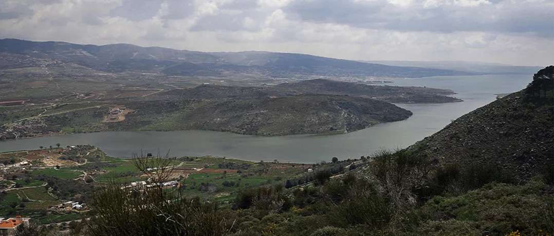
The Litani River originates from a cluster of springs known as the Al-Aliq springs, located approximately 10 kilometers west of the city of Baalbek in Lebanon’s eastern Bekaa Valley at an altitude of around 1,000 meters above sea level. From its source, the river flows southward through the western Bekaa before filling the artificial Lake Qaraoun reservoir, Lebanon’s largest freshwater lake. It then turns sharply westward near the historic Beaufort Castle area and continues through southern Lebanon until it empties into the Mediterranean Sea near the coastal town of Qasmiyeh, north of Tyre.
Stretching approximately 170 kilometers, the Litani constitutes the longest river entirely contained within Lebanese territory. Its basin covers roughly 2,100 square kilometers and generates an annual discharge exceeding 700 million cubic meters of water by the time it reaches the sea. This hydrological capacity makes the river the backbone of Lebanon’s irrigation and hydroelectric infrastructure.
The river plays a critical role in supporting agricultural production across the Bekaa Valley and southern Lebanon, irrigating tens of thousands of hectares of farmland and supplying water to hundreds of towns and villages. Hydroelectric facilities connected to the Litani River Authority (LRA) generate a significant portion of Lebanon’s domestic energy supply, while irrigation projects sustain rural communities and agricultural economies throughout the region.
Beyond its economic importance, the river also possesses significant strategic value due to its geographic position. Located roughly 6 to 28 kilometers north of the Lebanese-Israeli border depending on the sector, the Litani effectively divides southern Lebanon into 2 distinct zones: the area between the border and the river, commonly referred to as “south of the Litani,” and the broader national territory beyond it. This natural division has historically influenced military planning, as the river’s valley and surrounding terrain create a defensive barrier that complicates troop movement and logistics.
Historical Zionist and Israeli interest in the Litani River
Interest in the Litani River predates the establishment of the “State of Israel” and can be traced back to early Zionist strategic thinking in the late 19th and early 20th centuries. The founders of the Zionist movement recognized that water resources would be essential for the development of agriculture and settlement in the region (especially with regards to its kibbutz). Consequently, many early proposals for the borders of a future “Jewish state” sought to incorporate major water sources into the territory of historic Palestine.
During the negotiations following World War I (1914-1918), Zionist leaders argued that the northern boundary of Palestine should extend into southern Lebanon in order to include the Litani River basin. At the 1919 Paris Peace Conference, representatives of the World Zionist Organization (WZO) presented memoranda advocating the inclusion of the Litani within the borders of the future Jewish homeland; in light of Theodore Hertzel’s “Der Judenstaat” (German for the “Jewish State”), which was a seminal 1896 pamphlet advocating for the establishment of an independent “Jewish state” as a solution to European antisemitism. Chaim Weizmann, one of the leading figures of the movement, highlighted that the river’s waters were crucial for sustaining agricultural expansion and supporting the expected influx of Jewish immigrants, thus making it “essential to the future of the Jewish national home.”
These proposals ultimately failed due to geopolitical considerations among the European powers. France, which obtained the mandate over Lebanon and Syria under the League of Nations system, insisted on maintaining Lebanon’s territorial integrity. The border between the French Mandate territories and British-controlled Palestine was eventually formalized in the 1923 Paulet-Newcombe Agreement, which left the Litani entirely within Lebanese territory.
Despite this diplomatic outcome, the river remained a persistent element in Zionist strategic discussions following World War II (1939-1945). Former Israeli Prime Minister (PM) David Ben-Gurion as well as former Chief of Staff and Minister of Defense Moshe Dayan had sought to incorporate the Litani into Israeli territory, claiming that it should form Israel’s northern border. This was reinforced with Israel’s ground offensive into Lebanese southern territories during the First Arab-Israeli War of 1948, before withdrawing to Ras al-Naqoura due to diplomatic pressure and the signing of the 1949 General Armistice Agreement.
 Former Israeli Prime Minister (PM) Ariel Sharon points to a map showing southern Lebanon in 1982
Water, religion, and strategic calculations
Water scarcity has long shaped political and strategic calculations throughout the Middle East. Israel’s water resources are primarily derived from the Jordan River basin, Lake Tiberias (Sea of Galilee), and underground aquifers (including in the West Bank), many of which are under increasing environmental pressure due to population growth and climate change. In this context, the relatively abundant waters of the Litani River have periodically been viewed by Israeli strategists as a potential supplementary and essential source.
Although Israel has never formally incorporated the Litani into its water infrastructure, discussions about the possibility of diverting the river’s waters have persisted in academic and strategic circles for decades. Some Israeli planners have argued that redirecting part of the Litani’s flow toward the Jordan basin could significantly alleviate water shortages and improve agricultural sustainability. Some proposals even envisioned large-scale irrigation schemes that would channel the river’s waters southward to support agricultural development in the Negev Desert.
Beyond hydrological considerations, the region south of the Litani also holds cultural and religious significance for certain Jewish communities. Notable historical sites associated with ancient Jewish scholarship are located in southern Lebanon, including the tomb of the ancient Babylonian rabbi, Rav Ashi, located near Houla, Marjeyoun. In this context, ultra-Orthodox Jewish Israeli pilgrims visited the site in March 2025, organized by the Israel Defense Forces (IDF), generating political uproar in Lebanon as well as illustrating how historical memory and religious heritage intersect with modern geopolitical tensions.
Despite the aforementioned cultural and hydrological dimensions, the primary strategic importance of the Litani River in Israeli planning has historically been military rather than religious or economic.
In conclusion, more than a century after the modern borders of Lebanon were defined, the Litani River remains a critical determinant of security, politics, and regional relations in southern Lebanon. In the context of the current armed conflict between Israel and Hezbollah, the Litani once again serves as a reference point in discussions about buffer zones, ceasefire arrangements, and the broader security architecture of the region.
-
-

-
Michella RizkThe Beiruter's Content Manager
-
-
-

-
Anthony ChamounResearcher/Writer at The Beiruter’s Political Desk
-
