

After years of drought and water shortages, flooding along the Euphrates displaced thousands in eastern Syria, highlighting the intersection of climate volatility, cross-border water politics, and the lingering consequences of war.
The Euphrates flooding and Syria's water crisis

The Euphrates River has been the lifeblood of civilizations for millennia. Flowing from Türkiye through Syria and Iraq before emptying into the Persian Gulf, it remains one of the Middle East's most important waterways, providing drinking water, irrigation, and hydroelectric power to millions of people.
For years, however, eastern Syria's relationship with the Euphrates has been defined by scarcity. Droughts, declining water levels, and damaged irrigation systems have repeatedly threatened the agricultural communities that lie along its banks. Yet in late May, the region found itself confronting the opposite problem.
A sudden rise in water levels along the Euphrates displaced more than 2,400 families, flooded homes and farmland, damaged critical infrastructure, and forced emergency evacuations across eastern Syria. According to Syria's Ministry of Emergency and Disaster Management, nearly 3,000 families suffered damage as authorities rushed to reinforce riverbanks, protect pumping stations, and move residents away from vulnerable areas.
The flooding offered a stark reminder that the challenges surrounding the Euphrates extend far beyond water scarcity. As climate pressures intensify and regional water management becomes interconnected, communities along the river are finding themselves vulnerable not only to drought, but also to the consequences of sudden changes in river flows
The river that connects three countries
The Euphrates may run through Syria, but most of its water originates elsewhere. According to the UN Food and Agriculture Organization, Türkiye contributes approximately 89 percent of the river's annual flow, while Syria contributes about 11 percent before the Euphrates continues into Iraq. The river's geography has long placed water management at the center of relations between the three countries, particularly during periods of drought, agricultural stress, or changing water demand.
Much of that relationship today revolves around Türkiye's extensive network of dams, particularly the Atatürk Dam, one of the country's largest hydraulic infrastructure projects. Built during the 1990s as part of Türkiye's Southeastern Anatolia Project, the dam provides electricity and irrigation capacity for southeastern Türkiye while also giving Ankara substantial influence over the volume of water flowing downstream into Syria and Iraq.
For decades, Syrian and Iraqi officials have expressed concern about the impact of upstream water management on downstream communities. During periods of drought, disputes have typically centered on insufficient river flows. The May flooding demonstrated that sudden increases in water releases can be equally disruptive.
The crisis also highlighted the degree to which eastern Syria remains dependent on decisions made beyond its borders. Communities along the Euphrates rely on the river not only for agriculture but also for drinking water systems, power generation, and transportation links. When river conditions change rapidly, the consequences can cascade across multiple sectors simultaneously.
When scarcity became flooding
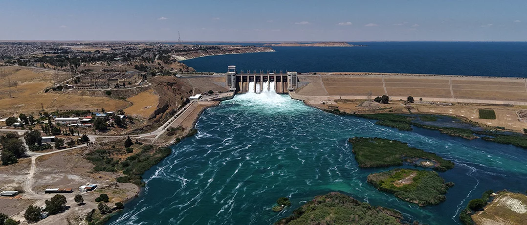
The immediate trigger for the crisis originated upstream. On May 26, Syria's Ministry of Energy announced that increased water inflows from the Turkish side had prompted authorities to open Gate No. 4 at the Euphrates Dam spillway. According to the ministry, the additional opening allowed an extra 100 cubic meters of water per second to pass through the system, raising total discharge along the Euphrates to approximately 1,800 cubic meters per second.
The ministry urged residents living near the riverbanks to exercise caution and stay away from the waterway, adding that precautionary measures were being coordinated with the Ministry of Emergency and Disaster Management and local governorates. Four days later, the Ministry of Energy reported that conditions along the Euphrates were gradually improving. The ministry announced that Gate No. 4 had been closed, reducing water discharge to approximately 1,400 cubic meters per second.
While Turkish media reportedly described the releases as controlled, Syrian officials argued that the timing of the water surge and delayed notification significantly worsened the situation. Syrian Energy Minister Mohammed al-Bashir stated that excessive upstream releases and insufficient warning were among the principal causes of the flooding.
The dispute reflects a longstanding challenge in managing transboundary rivers. Because the Euphrates crosses multiple national borders, effective water management depends not only on infrastructure but also on communication, coordination, and advance planning between governments.
A region already weakened
The floodwaters exposed vulnerabilities that had been building for years.
The Ministry of Emergency and Disaster Management reported that teams worked across a vast area stretching from the Euphrates Dam to the Iraqi border. More than 120 heavy vehicles were mobilized as crews reinforced 47 pumping stations, raised earthen barriers, and strengthened bridges. Three emergency shelter centers were established in Deir ez-Zor, where approximately 140 displaced families were accommodated, while designated crossing points equipped with rescue boats and ambulances helped transport dozens of humanitarian and medical cases between riverbanks.
Despite those efforts, significant damage occurred. Floodwaters inundated homes, schools, mosques, agricultural land, and infrastructure throughout Deir ez-Zor and Raqqa. The al-Mar'iya Bridge, the earthen bridge in Deir ez-Zor, and the al-Ashara Bridge were all taken out of service, disrupting transportation and isolating communities. Three children drowned while swimming in the Euphrates despite repeated public warnings from authorities.
The impact fell particularly heavily on communities living close to the river. Residents of small peninsulas and informal settlements built along the riverbanks faced some of the highest levels of exposure as water levels rose rapidly.
More than a flood
The significance of the disaster extends beyond the immediate damage.
In the weeks preceding the flooding, demonstrations had erupted in parts of Deir ez-Zor and Raqqa over deteriorating living conditions, inadequate public services, and dissatisfaction with government wheat procurement prices. The flood therefore struck a region already grappling with economic hardship and frustration over the pace of recovery.
Years of conflict have damaged infrastructure, weakened public services, constrained investment, and left many local systems operating with limited capacity. Climate pressures have compounded those challenges, contributing to recurring droughts, shifting rainfall patterns, and volatile river conditions.
The result is a region vulnerable to both extremes. Low river levels threaten crops, drinking water supplies, and electricity generation. Sudden surges threaten homes, roads, bridges, and irrigation networks. In statements carried by SANA, Syria's state news agency, officials framed the response as part of a broader effort to strengthen resilience in the eastern provinces. During a visit to Deir ez-Zor following the flooding, President Ahmed al-Sharaa directed ministries to rebuild damaged bridges and improve infrastructure throughout the region.
The floodwaters have largely receded, but the underlying challenge remains. Eastern Syria's future will depend not only on how much water flows through the Euphrates, but on whether the region can rebuild the infrastructure and institutions needed to manage an increasingly unpredictable river.
-
-

-
The Beiruter
-
