



From Ottoman navigators and French military surveyors to American intelligence analysts and UN peacekeepers, five maps examine how successive authorities have understood and defined Lebanon's geography.
Lebanon, a history in five maps

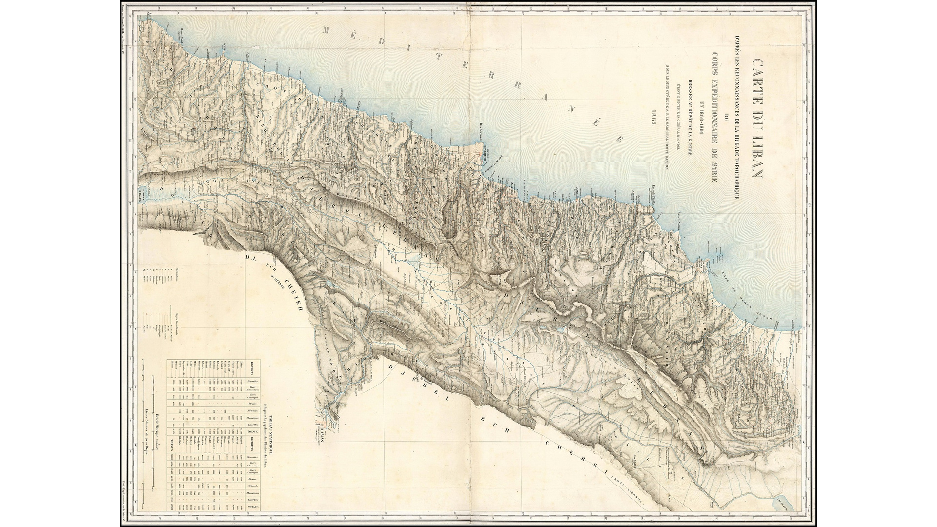
Lebanon's modern borders are little more than a century old, but the territory they enclose has appeared on maps for hundreds of years. Long before the establishment of Greater Lebanon in 1920, Ottoman navigators documented its coastline, European military surveyors recorded its mountains and settlements, and foreign powers debated the boundaries of its territory. But how did the priorities of those mapping Lebanon change as the country emerged as a modern state? The answer lies partly in the purposes these maps served. Some guided Mediterranean sailors, while others supported military operations, defined political territories or documented an independent republic and its disputed borders. Spanning nearly five centuries, these five maps trace the changing purposes of cartography and the political decisions defining Lebanon's territory. The earliest map in this collection belongs to Kitab-i Bahriye, or Book on Navigation, a maritime guide compiled by the Ottoman admiral and cartographer Piri Reis in 1525. The surviving illustration, preserved in a manuscript produced largely in the seventeenth century and now held by the Walters Art Museum in Baltimore, depicts the eastern Mediterranean coastline as far as Beirut. Its elaborate compass roses, coastal settlements and illustrated landmarks emphasize the coastline, while the mountainous interior receives comparatively little detail. There are no national borders separating the territories that would eventually become Lebanon, Syria and Israel. The map was compiled during the reign of Sultan Suleiman the Magnificent, roughly a decade after the Ottoman conquest of Syria and Egypt in 1516–17 brought the eastern Mediterranean coast under Ottoman rule. Drawing on the maritime knowledge available to Ottoman sailors, Piri Reis compiled approximately 240 maps and nautical charts covering Mediterranean ports, islands and coastlines, including separate illustrations of Tyre and Tripoli. The emphasis on coastal geography was therefore both practical and imperial. Designed to guide sailors, the work documented a region recently incorporated into the Ottoman Empire, centuries before Lebanon emerged as a distinct political state. More than three centuries later, French military cartographers were documenting Lebanon's mountains, settlements, and religious communities in the aftermath of a major political crisis. Published in 1862 by the French Dépôt de la Guerre, the military cartographic department, Carte du Liban drew on reconnaissance from France's 1860–61 expedition to Ottoman Syria. Dépôt de la Guerre / American Geographical Society Library, University of Wisconsin–Milwaukee / Library of Congress, World Digital Library. The expedition followed deadly sectarian violence in Mount Lebanon and Damascus, which prompted European intervention and negotiations over the region's administration. In 1861, Mount Lebanon became an autonomous Ottoman district governed under a special arrangement involving the European powers. The map documents mountains, roads, rivers and settlements across an area considerably larger than the autonomous district itself, extending into neighboring parts of Ottoman Syria. Particularly revealing is its population table, which classifies inhabitants by district and religious community. Geography and demography appear side by side, as French surveyors documented both the terrain and its religious communities amid debates over Mount Lebanon's governance. The map also demonstrates how fluid the geographical meaning of Lebanon remained. Although its title identifies the territory as Liban, the area surveyed did not correspond precisely to either the Ottoman administrative district or the borders of the modern republic. By 1926, Lebanon's political geography had changed considerably. A map produced by the Bureau Topographique de l'Armée française du Levant depicts Greater Lebanon as a distinct political unit alongside the State of Syria, the Alawite State and Jebel Druze, all under French mandatory administration. The transformation followed the collapse of the Ottoman Empire after the First World War. On September 1, 1920, French High Commissioner Henri Gouraud proclaimed Greater Lebanon, incorporating Beirut, Tripoli, Sidon, Tyre, the Bekaa Valley and other districts into the former territory of Mount Lebanon. These additions substantially expanded Lebanon's territory and altered its religious composition. Historian Fawwaz Traboulsi, in A History of Modern Lebanon, argues that the boundaries established in 1920 created a political entity that had not previously existed within those frontiers. The 1926 map captures this new arrangement. Its legend distinguishes territories and administrative divisions under the French Mandate, depicting Greater Lebanon as a defined political unit still subject to French authority. That same year, Lebanon adopted a constitution establishing the institutional foundations of the republic, including provisions for religious representation in public life. The map therefore documents a pivotal stage in the transition from Ottoman provincial administration to the political territory of the modern Lebanese state. A very different portrait emerges from the United States' Central Intelligence Agency's Atlas of the Middle East, published in January 1993, shortly after Lebanon's fifteen-year Civil War ended in 1990. Rather than concentrating on the creation of borders, the two-page spread presents Lebanon through its physical geography, population, economic activity and land use, mapping cities, roads, administrative divisions and agricultural production. The atlas also includes a historical timeline and demographic information. Its publication followed the 1989 Taif Agreement, which helped bring the Civil War to an end and redistributed political authority within Lebanon's confessional system. The country was entering a period of reconstruction after years of conflict, displacement and extensive damage to infrastructure. Yet the atlas offers little indication of the territorial fragmentation that had characterized the war. Its emphasis instead falls on the geographical and economic characteristics of an established state. The contrast with the French maps is revealing. Where nineteenth-century surveyors documented religious communities and colonial administrators delineated political territories, the CIA presented Lebanon through the statistical categories of a modern national atlas. The final map, produced by the United Nations Interim Force in Lebanon in 2018, returns to the question of boundaries. It depicts southern Lebanon through the geography of international peacekeeping, identifying the Blue Line, the Litani River, towns, observation positions and the operational sectors of UN forces. The Blue Line was established by the United Nations in June 2000 to verify Israel's withdrawal from southern Lebanon, following an occupation that had lasted in varying forms since 1978. Although it serves as a reference for monitoring violations, it is not an internationally agreed border. To identify the withdrawal line, UN cartographers drew on the 1923 Anglo-French boundary agreement and the 1949 Lebanese-Israeli Armistice Demarcation Line, underscoring the continued relevance of historical territorial arrangements. The 2018 map distinguishes the Blue Line from other boundaries and military sectors, highlighting the complexity of southern Lebanon's territorial geography. Its significance is particularly timely as UNIFIL approaches the end of its mandate on December 31, 2026, following the Security Council's decision to conclude the mission and begin an orderly withdrawal in 2027. Unlike the French Mandate map of 1926, which depicts the establishment of a political territory, the UN document records an internationally monitored line whose legal status remains distinct from that of a sovereign border. Across five centuries, the maps trace a progression from maritime navigation and imperial surveying to territorial administration, national geography and international peacekeeping. They also reveal a persistent feature of Lebanon's history. The country's geography has been documented by successive authorities, while the political meaning of its boundaries has remained subject to negotiation and dispute.An Ottoman view of the Mediterranean
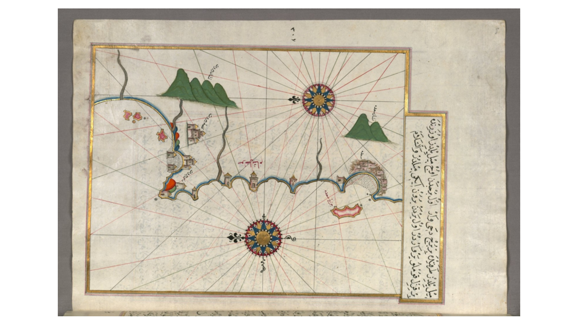 Piri Reis / Walters Art Museum, MS W.658, fol. 316a / David Rumsey Historical Map Collection
The French survey of 1862
Greater Lebanon under the French Mandate
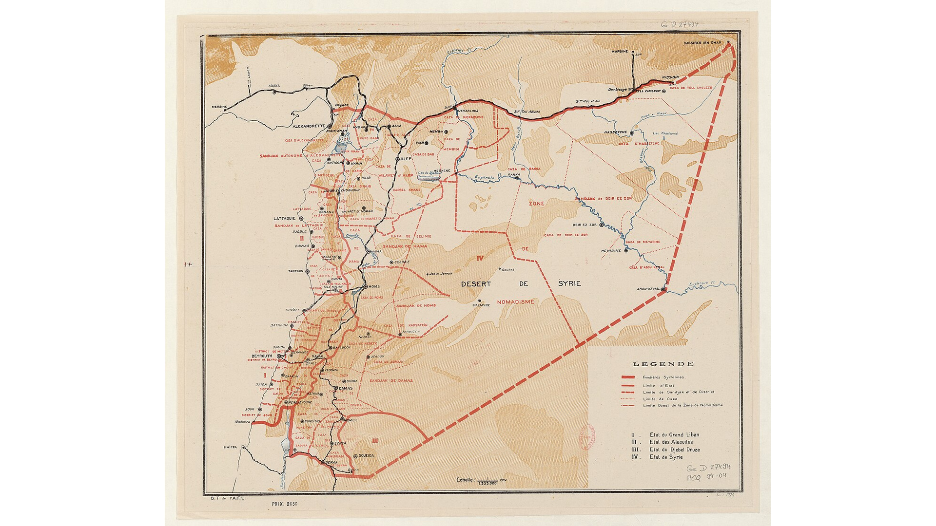 Bureau Topographique de l'Armée française du Levant / Bibliothèque nationale de France, département Cartes et plans, GE D-27494.
Lebanon after the Civil War
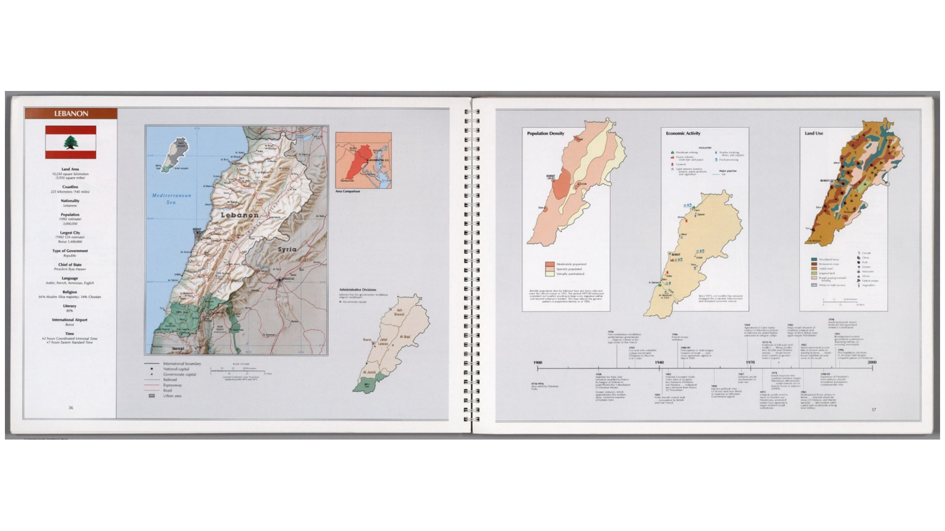 Central Intelligence Agency / David Rumsey Historical Map Collection.
The Blue Line and Lebanon's southern frontier
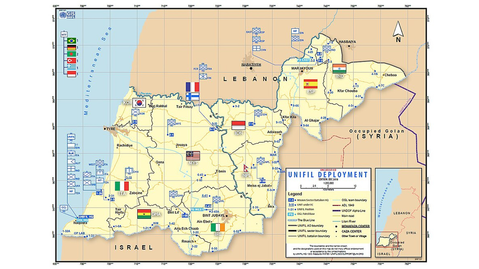 United Nations Interim Force in Lebanon (UNIFIL) / Wikimedia Commons, CC BY-SA 4.0.
-
-

-
The Beiruter
-
